


It's crazy how many times I've seen drones being launched from Lady Macquaries Chair – that then fly over Sydney Harbour and the Opera House. The drone operators are more than likely blatantly defying CASA's 'permanently restricted' no-fly zone. I say blatantly as you can see their drones manoeuvring dangerously in airspace where float planes are flying.
Many drone flyers who break these laws seem to be tourists who hide behind the imaginary 'I didn't know' clause. They also feel safe in the knowledge that by the time there was trouble with any online footage they posted, they'd be back overseas out of reach of Australia's CASA (Civil Aviation Safety Authority).

Most of these no-fly drone rules are in place because of the large number of helicopters, float planes and commercial flights in an area, though it's not just the dangerous aerial collisions that matter. A drone dropping out of the sky due to electronics or parts failure, or depleted batteries can also be very dangerous if they crash landed on unsuspecting people or wildlife. In fact, not many people know that it is against the law to fly over, nor within 100 meters of marine animals.
It is always a battle for CASA to enforce these laws, or educate the public, and in an effort to simplify this process, they have launched the first release of the Department of Infrastructure, Transport, Regional Development, Communications and the Art’s new drone map that shows the rules for 7,610 different areas managed by 15 different agencies, with more to be digitised in the future.
For example, the map shows drone laws around parks and correctional facilities across Australia that have restrictions.
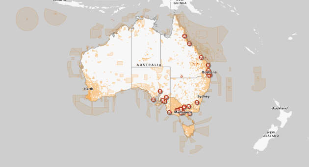
The Department hopes the free digital and geospatial map of local laws will help increase awareness of and compliance with drone laws.
The map can be integrated into drone software applications to help with flight planning, thanks to open data and a free application programming interface.
The move comes as CASA has increasingly tightened Australia's drone flying rules. In 2021, the CASA introduced a $40 registration fee for drones weighing over 500g that are used for commercial purposes.
The department is welcoming feedback to help improve the functionality of its new map. To view it and provide your feedback, visit www.drones.gov.au/policies-and-programs/initiatives/drone-rule-digitisation.
In fact, we have already seen some sections where the maps have very limited data which may lead to confusion where you can & can't fly. So the department does need your feedback!
But the department is not the only ones that create maps for drone use and you can find a number of great drone safety apps here for you to download.
To show you of the dangers of falling drones, watch this scary clip (below) of a car being hit by a falling drone on the Sydney Harbour Bridge. As mentioned by the driver – if he was going just slightly faster, the drone would have crashed through his windshield and may have caused a head on collision.
P.S. If you are reading this CASA, go down to Lady Macquaries Chair any evening and you'll have plenty of work to do!